The Lac La Motte North property is located in the prolific mining area of Abitibi, Quebec in the La Motte Township, approximately 40 kilometers Northwest of the city of Val-d’Or on N.T.S map-sheets 32D/08 & 32C/05. The property has excellent infrastructure support and is well located with respect to highways, access roads and railway. It is accessible by paved and gravel roads from the town of Amos via route 111 going east for 6 km then by following the same route going south for 44 kilometers, then travelling west on Chemin Simon Robitaille to the far west part of the property. Railway line is located just 15 kilometers northeast of the property.
Qualified manpower, contractors, electricity, mining suppliers and services necessary to exploration and mining operation are available at the mining town of Val-d’ Or and in the general district where several gold and base metals mines are active all year round.
The climate around the general area of the property is characterized by mild summer and long winters, generally extending from late October until mid to late April.
Topography of the property is fairly moderate with areas of low ground characterized by gentle rolling hills and relatively flat-laying land typical of glaciated landscapes. The property is located on the east side of Lac La Motte at an approximate elevation of 310-330 meters above sea level. Rock exposure is very limited.
The property consists of thirteen contiguous claims covering a total of 586.05 hectares located in map sheet area 32C/05 & 32D/08. The property hosts the north extension of the Lac La Motte lithium prospect known in this report as Lac La Motte north, centered at GPS 720491 E and 5362324 N.
LAC LA MOTTE PROJECT: GEOLOGY
Lac La Motte North property is located in the Superior Province of the Canadian Shields, which extends from Manitoba to Quebec covering approximately 750,000 square kilometers within the province of Quebec. The Archean Province is divided into a number of sub provinces based on their lithological, metamorphic, geophysical and structural characteristics. The property is located within the Abitibi Sub Province which is bordered by the Pontiac- Sub Province to the south and the Opatica Province to the north. The boundary between the Pontiac and Abitibi Sub Provinces is marked by the regional scale Cadillac Tectonic zone, a structurally complex zone which saw the greenstone belt of the Abitibi Sub Province thrust over the Pontiac Sub Province.
The subject property is located within the central part of La Corne pluton of the Preissac- La Corne Batholith. Rock outcrops cover approximately 5 % of the property area. The major rock units found on the property are hornblend granodiorite, and biotite schist. Pegmatite dykes occur within the intrusive rocks and in the adjoining sedimentary rocks. Sedimentary rocks are highly metamorphosed. The contacts with the intrusive are usually irregular and known to be prospective for lithium bearing pegmatites in the Abitibi region.
Several parallel pegmatite dykes trending northwest-southeast in the contact area between the metasediments and the Lacorne batholiths intrusives exposed in the vicinity of both Lac La Motte and Lac La Motte North target areas. Dykes usually invading fractures in altered metasedimentary (biotite schists and hornblende schists) as well as rocks of quartz monzonite intrusive.
All pegmatite dykes exposed on or close to the subject property (Lac La Motte prospect) are trending northwest-southeast. The spodumene-bearing pegmatite dykes are associated with and hosted by the monzonite and the granodiorite of the Lacorne Batholiths which is considered the main source for lithium mineralization and contain aggregates of spodumene and beryl.
A gabbro diabase dyke intruded La Corne Batholith rock units as well as the metasedimentary rocks, the dyke crosses the southern part of the property in a northeasterly direction and considered the youngest rocks on the property.
Other Projects in the Area
The Quebec lithium (currently North American Lithium Mine owned by Sayona Mining) mine property is located approximately 16 kilometers east-northeast of the subject property. Quebec lithium mine is considered the biggest and the only passed producing lithium mine in Quebec.
LAC LA MOTTE PROJECT: EXPLORATION WORK
Historical Exploration Work
The earliest record of work completed on the property dates back to 1954 when Lac La Motte lithium prospect was discovered by traditional prospecting. Spodumene-bearing pegmatite bodies also have been discovered in several other areas on the property and in the regional area of Lac La Motte. Historical Diamond Drilling on the property has yielded results as high as 1.65% Li20.
Medaro Exploration Work
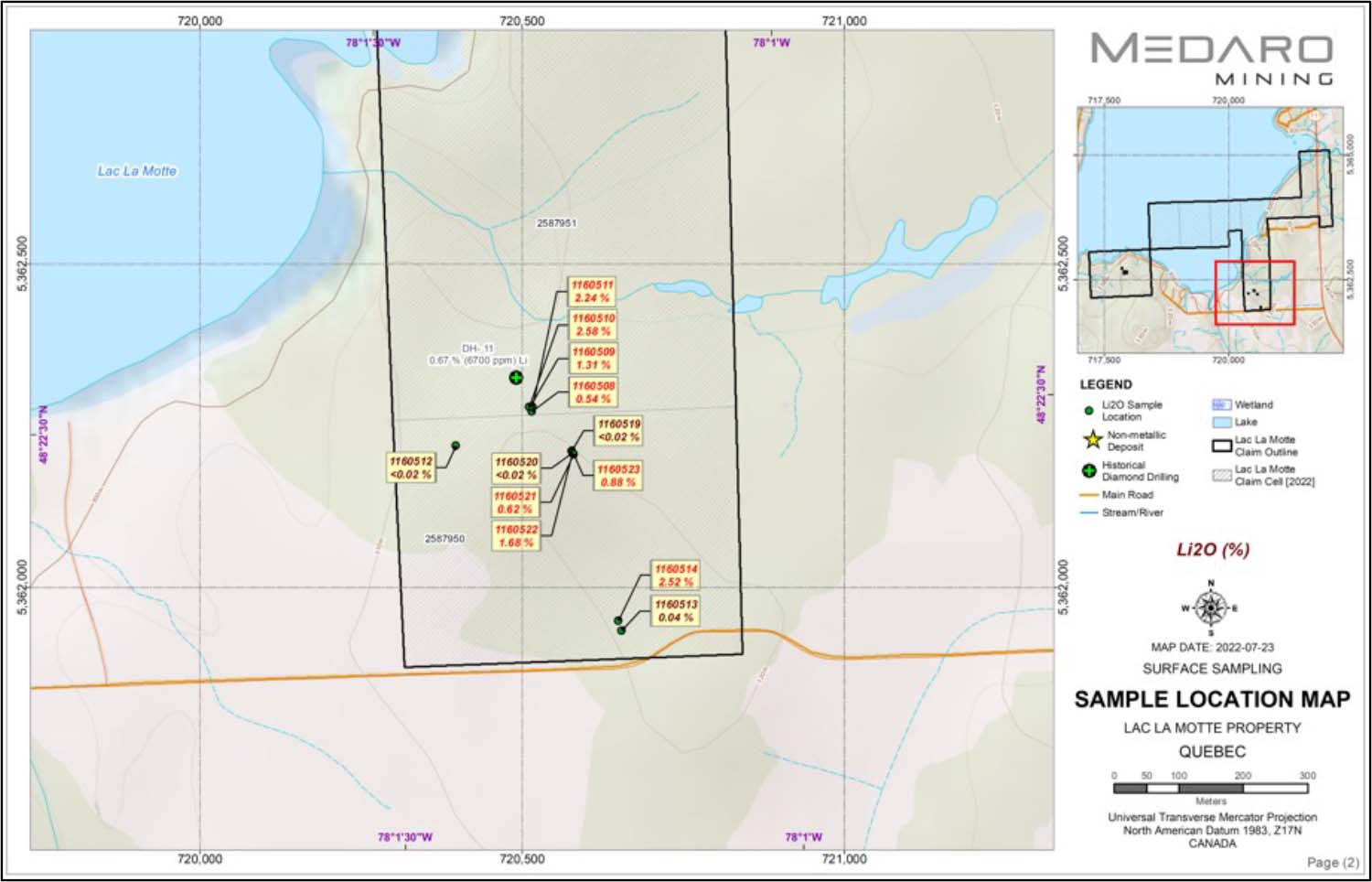
Surface sampling work was completed during the months of May-June 2022 and included prospecting, mapping and sampling of known lithium showings and other areas on the Property. The scope of work was to confirm the historical lithium occurrences and drill holes documented for this area, and to find targets for the current exploratory drill program. The surface samples result from the main La Motte showing indicate lithium oxide (Li2O) values in the range of less than 0.02% Li2O to 2.58% Li2O.
Diamond Drilling
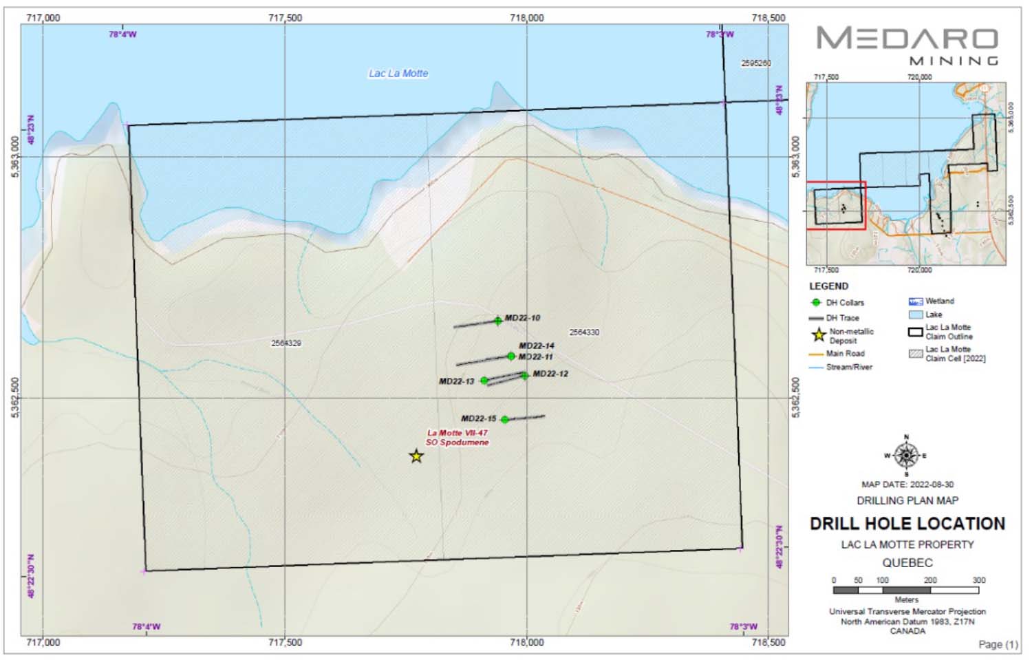
Medaro contracted Forage Hebert Inc. (Herbert) to drill a series of NQ size diamond drill holes on lithium targets and showings on the Property. A total of 18 drill holes with over 2400 m NQ size diamond core drilling was completed on the Property. The focus of the drill program was 500 long pegmatite trends partially exposed at surface with widths in the range of 0.5 to 2 meters. Several drill holes in the current work program intercepted lithium pegmatite zones. A core shack located about 40 kilometers from the Property was used for drill core logging, sample preparation and storage. The drilling data is being compiled. The drill core samples were prepared and shipped to Activation Laboratories in Ontario. Several holes intersected lithium pegmatites of variable widths.
Highlights of 2022 surface samples locations and assays. Click image to enlarge.
2022 Drill hole locations. Click image to enlarge.