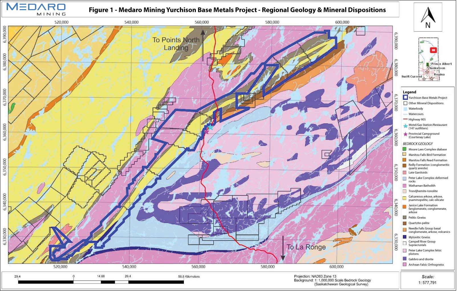
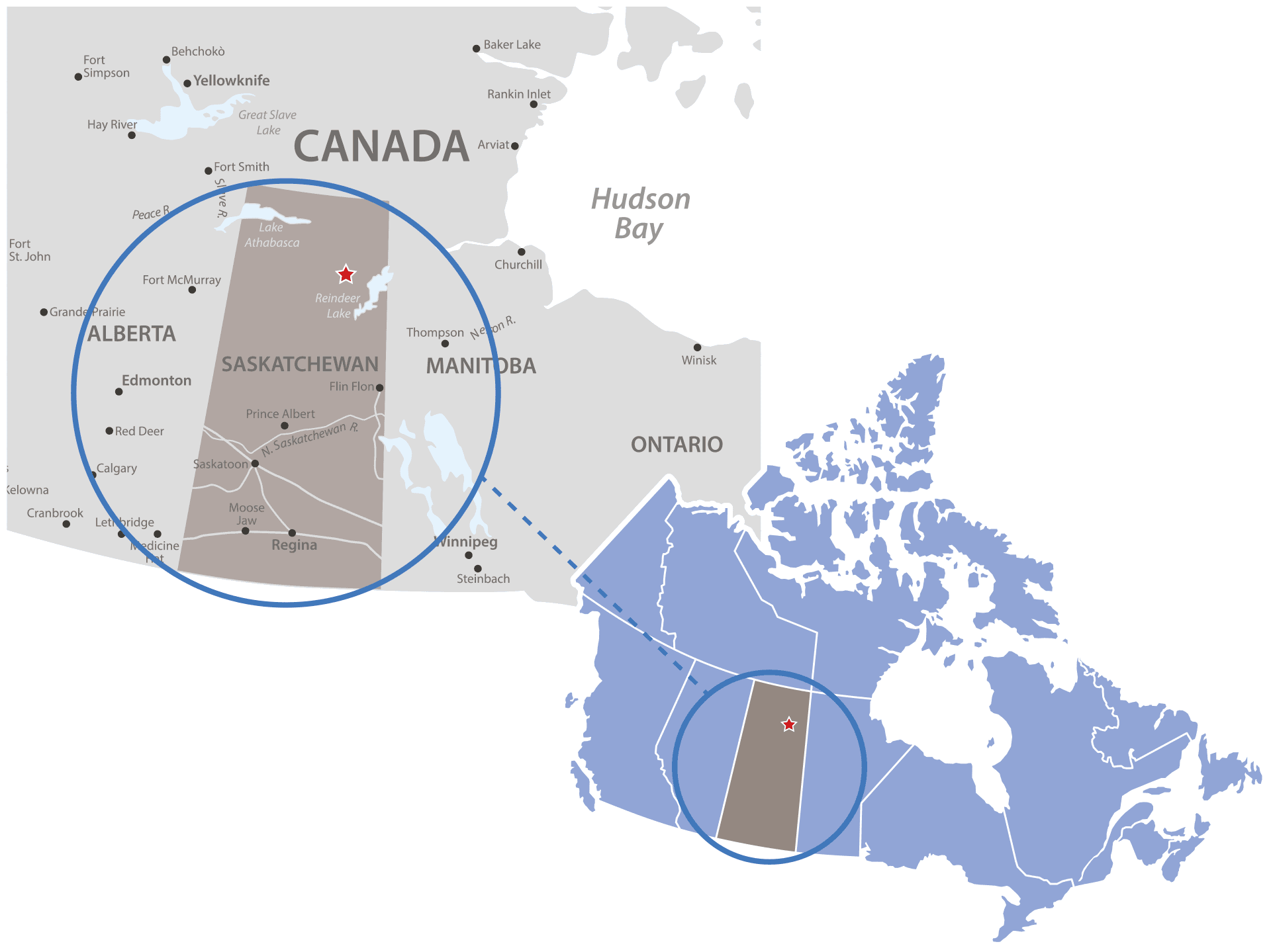
The Yurchison Project consists of 12 claims totaling 55,934 hectares in the Wollaston Domain of northern Saskatchewan, Canada. This contiguous set of claims covers an extensive package of Wollaston Supergroup metasediments in an area known for its uranium and base metal potential.
Access to the area is enhanced by Highway 905 running through the middle of the property. A planned all-weather road between Highway 905 and the communities of Wollaston Lake and Hatchet Lake is set to run adjacent to the northeastern section of the claims.
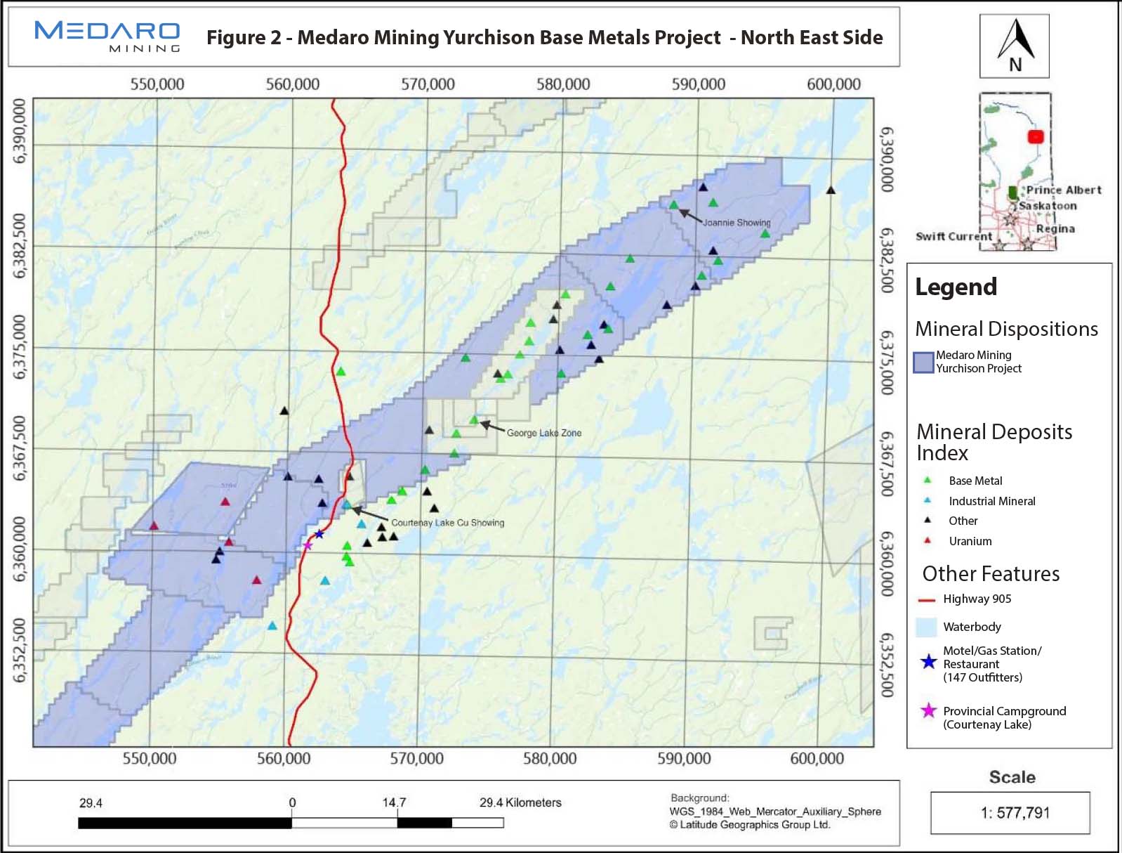
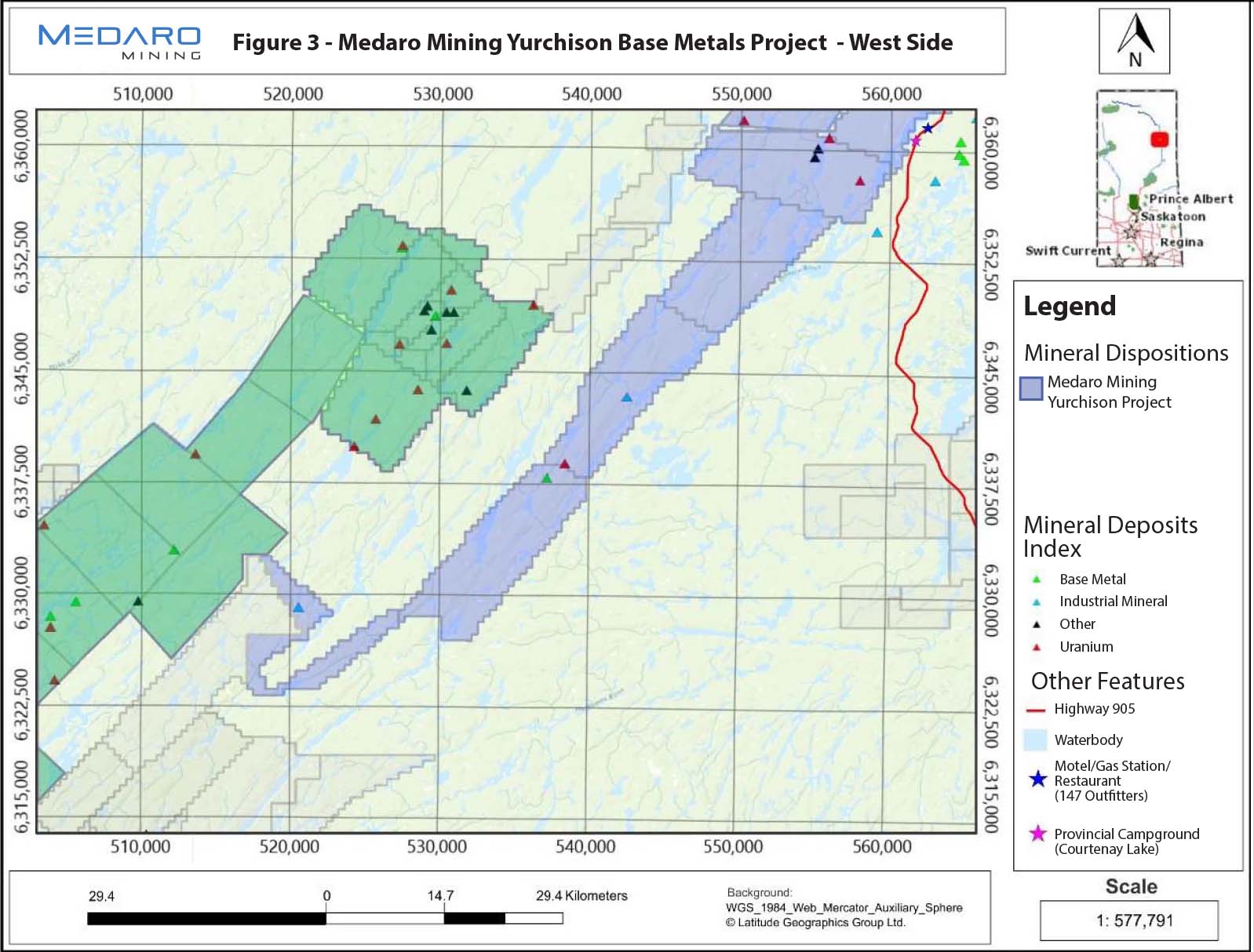
There is a significant amount of historical work on the property and surrounding areas, including prospecting, mapping, rocks, till and overburden sampling, geophysical surveys and diamond drilling. Historical showings/deposits in the area include several U, Pb-Zn, Mo, and/or Cu occurrences, for which there are more than thirty records documented on the Property in the Saskatchewan Mineral Deposits Index (SMDI). A significant showing/ deposit include the George Lake Zn-Pb deposit (which occurs adjacent to the Medaro claims, SMDI 0663), and the Joannie Showing (SMDI 1704), just south of the Compulsion River. There are six uranium showings and several base metals occurrences located on the property which are summarized below.
(Source: https://www.saskatchewan.ca/business/agriculture-natural-resources-and-industry/mineral-exploration-and-mining/saskatchewan-geological-survey/saskatchewan-mineral-deposit-index-smdi). Based on this information, the southern part of the Property is considered more favourable for uranium exploration and the northern part is more favourable for other metals.
Great Plains Development Company of Canada located the showing, in 1969, while prospecting the sites of airborne anomalies (AF 64E05-0012). It is located one mile (1.6 km) north of the northeastern arm of Carol Lake on the Johnson River. The area is extensively drift covered. Geologically, the showing is located immediately north of the contact between Wollaston Group metasediments and Peter Lake Domain quartzofeldspathic gneiss which has been extensively intruded by granitic rocks. The showing was trenched (trench 2) and this exposed a yellow uranium-stained vein cutting red granite. One grab sample gave 0.28% U3O8 (uranium oxide).
The showing is located 0.18-mile (0.29 km) east of the midpoint on the east shore of Yurchison Lake. The outcrop lies within an area mapped by B. Scott as Wollaston Group unit 5 or fine- to coarse-grained, massive to well foliated meta-arkose with interlayers of variably biotitic psammite and calc-silicate gneiss. The showing occurs in an area which is overlain, chiefly, by swamp. The showing consists or a radioactive quartzitic outcrop (AB-11-4) which returned scintillometer readings of up to 5,000 cps (counts per second). The outcrop was found to contain uraninite specks and quartz stringers and returned assays of 0.148% U3O8 (0.126% U) and 0.003% MoS2 (molybdenum disulfide). Sixty-five meters (213.3 ft) to the north, prospectors located an outcrop (AB-11-2) of meta-arkose which is cross-cut by a 2 m (6.6 ft) long biotite-filled fracture. A grab sample returned 90 ppm U3O8 and 50 ppm Mo (molybdenum).
The showing was located, trenched and sampled by Great Plains Development Company of Canada Ltd. in 1969 (AF 64E05-0012). It is located one mile (1.6 km) northwest of the northern end of Yurchison Lake. The showing area is extensively drift covered. The granitic gneisses in the showing area have been subjected to intense shearing, along a northeast-trending plane, which gives the plutonic rocks a vague gneissic texture. The granites in the Jognson Lake area represent an early phase of the batholith. The radioactive occurrence was trenched and exposed veins with yellow uranium stain cutting red granite. Grab samples returned 0.021 and 0.028% U3O8.
The showing was located in the Great Plains Development Co. of Canada Ltd. Permit No. 4 in 1969 (AF 64E05-0012). It is located 1.5 miles (2.4 km) south of the eastern arm of Johnson Lake. The showing area, which is extensively drift-covered, was initially mapped as being underlain by Johnson River Inlier granite or fine-grained, vaguely gneissic, feldspar porphyroblastic biotitic granite gneiss. Due to strong shearing along a northeast-trending plane, the Johnson River Batholith plutonic rocks appear schistose and tend to grade, locally, into an augen gneiss. These gneisses represent an early phase of the batholith. The radioactive zone, which constitutes this showing, was trenched. This trenching exposed granite crosscut by narrow uranium-stained shear zones. Assays from trench No. 2 gave 0.06 to 0.44% U3O8 and 0.06% ThO2 (thorium oxide). One additional sample gave 0.15% ThO2. Further trenching in the Johnson Lake area exposed uranium mineralization giving 0.038 to 0.062% U3O8 and 0.029 to 0.048% ThO2.
The area of the showing was explored by Gulf Minerals Company, Occidental Petroleum, and few other operators between the period from 1968 to 1977. The showing consists of two anomalously radioactive boulder samples returning high scintillometer readings and uranium values. The boulders are located 0.37-mile (0.6 km) south of the southeast tip of a small triangle-shaped lake which is 0.8-mile (1.29 km) east of the north shore of Bailey Lake. Bedrock compilation geology shows the area underlying the showing to be underlain by Wollaston Group psammitic gneiss, variably fine to coarse grained, well foliated to massive and consisting of both calcareous psammite and biotite psammite. Boulder RG-6-3B consists of meta-arkose which registered scintillometer readings of 3000 cps. Subsequent analysis returned values of 0.085% U3O8 (0.072% U), 9 ppm Mo, 110 ppm Pb (lead) and 4 ppm Cu (copper). The boulder is probably locally derived. The second boulder comprising the showing (RG-6-4B) consists of granite gneiss. The boulder registered a scintillometer reading of 10,000 cps, along with values of 285.8 ppm U3O8 (242.4 ppm U), 74 ppm MoS2, 3 ppm Cu and 60 ppm Pb. (AF 74H08-0030).
Also refer to SMDI 1137. Rock samples are from historical trenches west of Yurchison Lake. Sample WA6O-350 (6359750 N, 555080 E): 2580 ppm U, 5130 ppm Mo, 990 ppm Pb. Samples WA6B-351-353 are all in the vicinity of 6359520 N, 554800 E. WA6B-351: 1280 ppm U, 3200 ppm Mo, 425 ppm Pb; WA6B-352: 760 ppm U, 6860 ppm Mo, 310 ppm Pb; WA6B-353: 958 ppm U, 2530 ppm Mo, 262 ppm Pb. All are total values. These are hosted by mafic (actinolitic) bands up to 10 cm wide and locally in fractures in metasedimentary rocks. The area is proximal to the Archean Johnson Lake Granite inlier.
The original showing, which was discovered by E. Partridge, is located on the northwest shore of Courtenay Lake 0.75 mile (1.2 km) southwest of the north tip of the lake. The original showing consists of an occurrence of pyrite with trace amounts of sphalerite and galena within George Lake Formation rocks. In 1992, two holes, CR92-5 and CR92-6, were completed at the showing. Drill hole CR92-5 encountered a well-developed silica-pyrite-pyrrhotite veinlet network within a series of brecciated and phyllitic weakly graphitic mudstones. The horizon contains disseminated, and stringer type, and blebby fracture fill pyrrhotite-pyrite mineralization which returned Pb-Zn values. Drill hole CR92-6 encountered chlorite-pyrite on joint surfaces, blebs and disseminations of arsenopyrite±galena and minor pyrite, and traces of chalcocite within an almost cherty silty interval within a series of biotitic siltstones.
The George Lake Northwest (C) Zone is a boulder occurrence (part of the George Lake boulder trains) is a 250 m (820.2 ft) long by 60 m (196.9 ft) wide area of frost-heaved boulders was outlined by Partridge in 1968 (AF 64E12-0021) and Karup-Moller and Brummer (1970). It was described as sphalerite and galena plus minor associated pyrite and pyrrhotite (present as flattened blebs) within whitish grey argillitic quartzite boulders and grey to black meta-argillite boulders. Within this area, one finds a stratiform zone of frost heaved boulders (15 m wide) in which 5 to 10% of the boulders are net-veined by injected quartz. Up to 5% pyrite, arsenopyrite, and galena occur within and adjacent to the quartz veining. Samples of this vein-style mineralization returned up to 7.20 oz/ton Ag, 0.005 oz/ton Au, 0.24% Pb, and 0.34% Zn.
The showing is located 400 ft (122 m) southeast of a bay at the southwest end of Spence Lake. It consists of a frost heaved block of vein quartz float which contains galena, pyrite, and arsenopyrite. A grab sample returned 27.06 oz/ton Ag and 4.84% Pb. In the immediate vicinity, an outcrop of biotitic grey quartzite was found to contain trace amounts of pyrrhotite. Approximately 1.14 miles (1.83 km) to the southwest of the showing, prospecting located frost heave of mineralized argillaceous quartzite and vein quartz. Three samples from this site returned 1.78, 7.20, and 5.70 oz/ton Ag (silver).
The occurrence is part of a fluvio-glacial boulder train (Karup-Moller and Brummer, 1970). It is located east of George Lake and 3.62 km (2.25 miles) east of SMDI 2402. The boulders which constitute this showing were outlined by Karup-Mollar and Brummer (1970) who described the occurrences as sphalerite-bearing quartzitic float. No assays were conducted on the boulders. Partridge (AF 64E12-0028) assayed an area he mapped as outcrop of argillaceous quartzite near the occurrence. The sample returned a value of 4.09% Pb and 8.28% Zn. Trace chalcopyrite was also noted.
Historical exploration work was conducted from 1968 to 1998 which included geological mapping, trenching, ground geophysical surveys and drilling. The showing consists of a mineralized outcrop which is located 150 m (492.1 ft) southeast of the Compulsion River. The sulphide mineralization in a 12 m long by 9 m wide area includes pyrite, pyrrhotite, chalcopyrite, sphalerite, and molybdenite which occurs as disseminations and fracture fillings within outcrops of white to grey quartzite. The showing was trenched and exposed quartzite and minor pegmatite, arkose, and biotite gneiss. Samples returned assay values of 1.12 to 0.26% Zn, 78 to 256 ppm Cu, 41 to 167 ppm Pb, and 44 ppm Mo. In 1997, 7 drill holes were completed immediately to the east of the showing. All encountered minor Pb-Zn mineralization.
The Company intends to complete a two-phase exploration
work program. Phase 1 will include a re-assessment of historical exploration data related to prospecting, mapping, and sampling; and relogging of available historical drill core to better understand the stratigraphy and its relationship with the sulphide mineralization and the mineralizing systems. A ground prospecting mapping and sampling work will also be completed during this phase to confirm historical mineralization areas and their extensions. A Phase 2 program will include ground and airborne geophysical surveys to generate targets for further exploration, and diamond drilling.